Multi-State FCC Licensing
Building on its existing radar deployments, StormQuant is advancing plans to expand operations into additional states nationwide. As part of this effort, the company has secured additional Federal Communications Commission (FCC) licenses for Florida, Georgia, and South Carolina and is actively pursuing FCC commercial authorizations in key markets, including California, Texas, Alabama, and others.
“2025 was a breakout year for the StormQuant team,” said Edward Rossi, CEO of StormQuant. “Each successful use case demonstration further validates our platform’s position as a must-have, next-generation weather technology.”


StormQuant’s proprietary platform combines an advanced, compact X-Band radar with the company’s patented meshing software to deliver enhanced data resolution and high-fidelity 3D imagery, supporting more accurate and timely forecasting. With detection sensitivity that significantly exceeds industry standards, StormQuant’s radar stands apart in a class of its own.
“2025 was a breakout year for the StormQuant team,” said Edward Rossi, CEO of StormQuant. “Each successful use case demonstration further validates our platform’s position as a must-have, next-generation weather technology.”
StormQuant’s proprietary platform combines an advanced, compact X-Band radar with the company’s patented meshing software to deliver enhanced data resolution and high-fidelity 3D imagery, supporting more accurate and timely forecasting. With detection sensitivity that significantly exceeds industry standards, StormQuant’s radar stands apart in a class of its own.
Rapid-Scan RHI Delivers Enhanced Situational Awareness & Forecast Accuracy
StormQuant’s compact weather radar is engineered to deliver high-performance weather intelligence in an installation-ready system suitable for both commercial and government operations. Developed through rigorous testing and iterative refinement, the radar features a software-controlled hardware architecture with robust operational capabilities, delivering an efficient, reliable, and scalable solution.
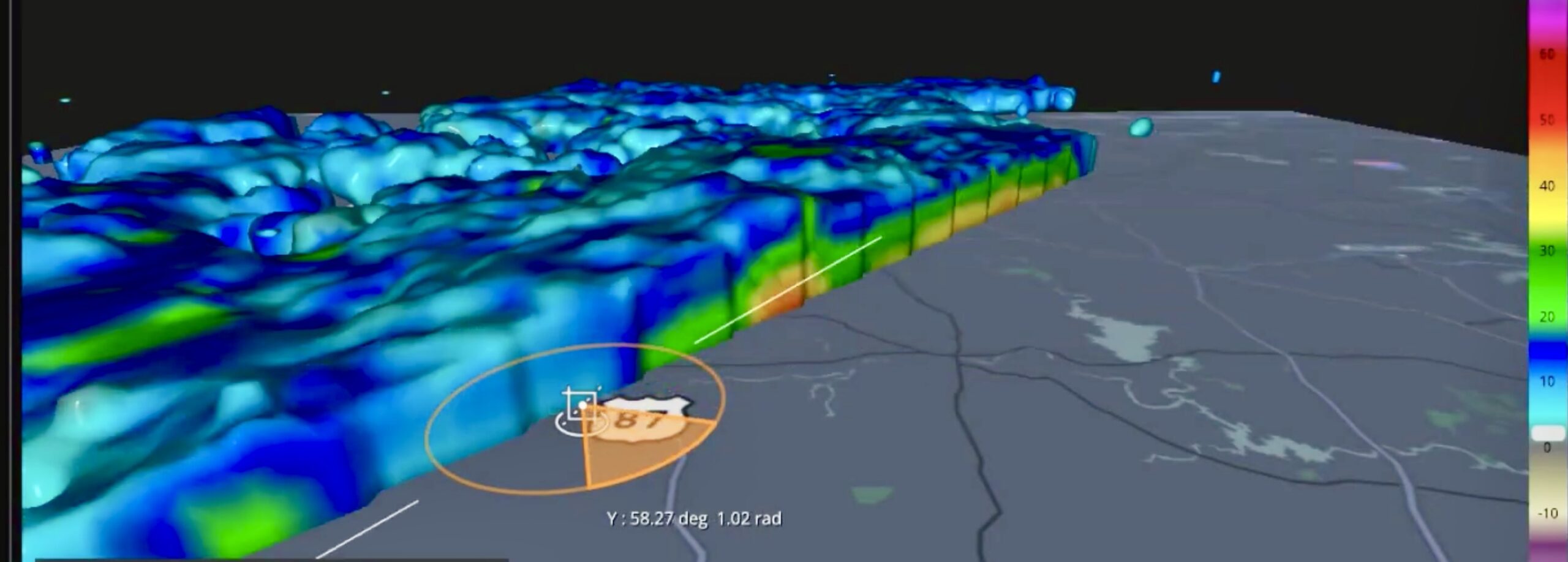
Unlike legacy radar systems that focus primarily on horizontal scans, StormQuant’s radar can also deliver real-time vertical profiles of storms through Range Height Indicator (RHI) scanning. This dual capability allows operators to assess storm height, intensity changes, and vertical structure—critical factors for severe weather monitoring, aviation safety, and emergency response.
Operators can configure sector sizes and elevation counts to achieve data refresh rates in tens of seconds, supporting rapid updates during evolving weather events. RHI scanning is a standard operational feature across all StormQuant radars, ensuring consistent performance without specialized configurations.
Unlike legacy radar systems that focus primarily on horizontal scans, StormQuant’s radar can also deliver real-time vertical profiles of storms through Range Height Indicator (RHI) scanning. This dual capability allows operators to assess storm height, intensity changes, and vertical structure—critical factors for severe weather monitoring, aviation safety, and emergency response.

Operators can configure sector sizes and elevation counts to achieve data refresh rates in tens of seconds, supporting rapid updates during evolving weather events. RHI scanning is a standard operational feature across all StormQuant radars, ensuring consistent performance without specialized configurations.
Versatility & Mobility When It Matters Most


StormQuant’s compact radar design enables rapid deployment wherever and whenever critical weather intelligence is needed. Unlike legacy NEXRAD and other conventional radar systems that often require months of on-site construction and assembly, StormQuant radars are transport-ready and designed for fast installation. From unloading to the transmission of actionable weather data, a StormQuant system can be fully operational in as little as a few hours.
“This mobility delivers a decisive advantage during emergencies, temporary operations, and time-sensitive missions,” said Tristan Rizzi, Capt. SEAL, USN (Ret.), President of StormQuant. “This can be especially important where traditional infrastructure is impractical or unavailable.”
When permanent support structures are not available, StormQuant’s mobile Scorpion Tower provides a self-contained deployment option, enabling true “weather anywhere” capability. Data can be transmitted via any available wired, cellular, WiFi, or satellite network. This flexibility allows operators to establish high-performance radar coverage in remote locations, disaster zones, or rapidly evolving operational environments—without sacrificing data quality or reliability.

The Future Of Weather Intelligence Is Here With StormQuant
StormQuant brings to market a distributed, adaptive, and resilient weather radar architecture. Our advanced capabilities better support informed decision-making for agencies responsible for public safety, infrastructure protection, and environmental monitoring.
With rapid deployment, flexible configuration, and high-resolution sensing, StormQuant enhances coverage where it is needed most—improving situational awareness and ensuring continuity of operations during extreme weather, infrastructure disruptions, or evolving mission demands.